


Introduction to Map and Compass
This course is limited to 12 participants.
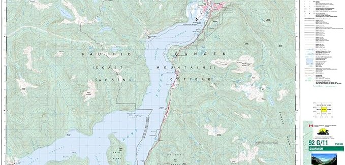
Pre-requisite: In order to participate in the hands-on activities of the course, you need a compass. While a compass with declination adjustment and a mirror would be easier to work with, for the purpose of this course any compass would also work. Any topographical map of Squamish area , e.g. Canadian Top map of Squamish 92-G/11.
Both items above can be purchased from Valhalla Pure Squamish.
Learning Objectives: By the end of the session, participants will:
- Be familiar with navigation tools, such as maps, compasses, altimeters, etc.
- Be familiar with topographic maps, the features that distinguish them from other types of maps, and the reasons they are ideal for backcountry navigation.
- Be familiar with the anatomy of a compass and how to choose a compass for backcountry use.
- Understand the following concepts/symbols on a topographic map: Contour lines Basic colour/terrain indicators Scale Declination Latitude/longitude grid UTM grid The following concepts will be discussed in detail: Interpreting real-life terrain features from a topographical map Setting declination on a compass and its importance Taking a bearing from a map Setting a bearing onto a map Taking a bearing in the field Following a bearing in the field Resection (triangulation) Length: Allow 2 to 3 hours depending on the participants’ background.
All proceeds will go to Marine Search and Rescue.

Dates
June 17, 2024Time: 6:30-9:30
Cost: $10.00
Venue
Contact & Details
- Maddie Sterne
- 604-892-9092
- Website